
Last update
Space
Space offers unprecedented opportunities for development and progress. However, the increasing dependence of our societies on space for their day-to-day functioning also generates vulnerabilities. Like cyber defence, space will gain in importance as a key national security issue.
Luxembourg Defence will strive to implement the sector strategy described in the first Defence Space Strategy of 2022. This strategy defines concrete objectives for Defence in order to consolidate Luxembourg's role as a reference partner in the field of space, both nationally and internationally, by strengthening existing capabilities and developing new ones. Luxembourg, having its own space capabilities, can have a significant impact and thus provide its fair share to the overall security and defence effort.
Particular attention is being paid to the development of dual-use capabilities and the use of such in accordance with international law. In order to promote responsible behaviour in outer space and in support of the United Kingdom's initiative within the framework of the UN to develop norms of responsible behaviour in outer space, Defence will continue to limit access to Luxembourg's sensitive space technologies to partners who respect international law and human rights.
Medium Earth Orbit Global Services (MGS)
The MGS project authorises the acquisition and operation by the Directorate of Defence of satellite communication capacities from the O3b mPOWER constellation, developed by SES, terrestrial components in the form of a gateway and user terminals, as well as associated services. The total budget for the project is €195 million over a 10-year period.
The O3b mPOWER constellation is located in Medium Earth Orbit (MEO), at an altitude of 8,000 km, and is made up of satellites featuring a unique cutting-edge technology, with high throughput and low latency in the equatorial plane, enabling a secure sovereign network to be set up. The acquisition and operation of satellite communications capabilities is carried out through the Global Commercially Contracted Satellite Communications Support Partnership (GCC SatCom SP) established by Luxembourg and the United States under the auspices of the NATO Support and Procurement Agency (NSPA) in 2022.
The communications capacities acquired by the Directorate of Defence from SES will be guaranteed and may be shared with other Defence-approved customers or partners.
LUXEOSys
System description
LUXEOSys is a government satellite earth observation system delivering up to 100 very high resolution optical images per day. The system comprises a satellite and its ground segment.
The "NAOS" (National Advanced Optical System) observation satellite, equipped with a very high-resolution camera, will be placed at around 450km in a low polar orbit and will orbit the Earth 15 times a day, taking images of the whole Earth. The launch took place in August 2025 and the system will be operational by mid 2026.
This satellite system will be used for a large number of different applications, including:
- military operations
- security
- monitoring disarmament treaties
- observation of troop movements in a conflict zone
- human disasters and humanitarian aid
- natural disaster management
- climate change
This satellite will enable the Directorate of Defence to become an image provider for organisations such as the EU, NATO, the UN, the International Atomic Energy Agency (IAEA), our allied states and other civilian partners.
LUXEOSys in figures
- Orbit: 450 km
- Satellite speed: 8 km/s
- 1 revolution every 94 minutes
- 15 revolutions/day
- Hexagonal shape with a diameter of 1.84 m
- One image = 10x10 km area covered (2.5 Gigabyte)
- Service life: 7 + 3 years
- Minimum response time between request and available image = 17 hours

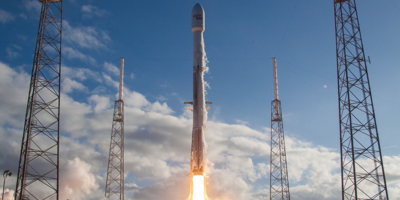
GovSat
GovSat is a public-private joint venture between the Luxembourg government and the private Luxembourg satellite operator SES. GovSat provides secure, reliable and accessible satellite communication services to governments. The GovSat-1 satellite was launched and has been fully operational since 2018. Thanks to its geostationary orbital position at 21.5° East, GovSat-1's coverage extends from 50° West to 90° East and from 70° North to 70° South.
In July 2025, the Luxembourg Government and SES today announced their plan for development of a second satellite for GovSat (LuxGovSat S.A.), the public-private partnership and 50/50 joint venture between SES and the Luxembourg Government that provides secure, reliable and accessible satellite communication services for governments. The law of 5 February 2026 authorises the Government to fund the acquisition, launch and operation of the GovSat-2 satellite, intended for government and military communications, as well as to acquire satellite capabilities.
GovSat-2 will be positioned over the European satellite arc. It will join GovSat-1 in augmenting reliable connectivity services for government customers over the region. The satellite will be built by Thales Alenia Space on its Spacebus 4000B2 platform.
© SpaceX